
Siesta Key topographic map
Interactive map
Click on the map to display elevation.
About this map
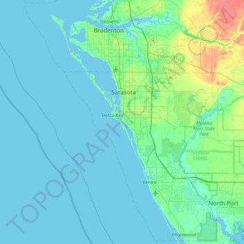
Name: Siesta Key topographic map, elevation, terrain.
Location: Siesta Key, Sarasota County, Florida, 34242, USA (26.93718 -82.85569 27.57718 -82.21569)
Average elevation: 5 m
Minimum elevation: -3 m
Maximum elevation: 41 m
Other topographic maps
Click on a map to view its topography, its elevation and its terrain.
Perico Island
Perico Island, Bradenton, Manatee County, Florida, 34215, USA
Average elevation: 3 m
Caladesi Island State Park
Caladesi Island State Park, Dunedin, Pinellas County, Florida, USA
Average elevation: 0 m
Caloosahatchee River
Caloosahatchee River, Lee County, Florida, 33920, USA
Average elevation: 8 m
Dry Tortugas National Park
Dry Tortugas National Park, Monroe County, Florida, USA
Average elevation: 0 m
Miami River
Miami River, Miami, Miami-Dade County, Florida, 33128, USA
Average elevation: 9 m
Lakeland Highlands
USA > Florida > Lakeland Highlands
Lakeland Highlands, Polk County, Florida, 33831, USA
Average elevation: 63 m
Fisher Island
USA > Florida > Fisher Island
Fisher Island, Miami-Dade County, Florida, 33109, USA
Average elevation: 3 m
Saint Augustine Shores
USA > Florida > Saint Augustine Shores
Saint Augustine Shores, St. Johns County, Florida, 32086, USA
Average elevation: 7 m
William Beardall Tosohatchee State Preserve
William Beardall Tosohatchee State Preserve, Orange County, Florida, USA
Average elevation: 4 m
Jensen Beach
USA > Florida > Jensen Beach
Jensen Beach, Martin County, Florida, USA
Average elevation: 5 m
Hallandale Beach
USA > Florida > Hallandale Beach
Hallandale Beach, Broward County, Florida, USA
Average elevation: 7 m
Daytona Park Estates
USA > Florida > Daytona Park Estates
Daytona Park Estates, Volusia County, Florida, 32724, USA
Average elevation: 20 m
Timber Pines
USA > Florida > Timber Pines
Timber Pines, Hernando County, Florida, 34606, USA
Average elevation: 11 m
Yeet Pond
USA > Florida > Palm Coast
Yeet Pond, South Coopers Hawk Way, Palm Coast, Flagler County, Florida, USA
Average elevation: 7 m
San Cruz Canal
USA > Florida > Cape Coral
San Cruz Canal, Cape Coral, Lee County, Florida, 33914, USA
Average elevation: 3 m
Delray
USA > Florida > Delray Beach
Delray, Southeast 1st Street, Delray Beach, Palm Beach County, Florida, 33483, USA
Average elevation: 8 m
Butler Beach
USA > Florida > Butler Beach
Butler Beach, St. Johns County, Florida, USA
Average elevation: 2 m
Presbyterian Villas Of Lehigh
USA > Florida > Presbyterian Villas Of Lehigh
Presbyterian Villas Of Lehigh, Lee County, Florida, 33936, USA
Average elevation: 10 m
Amelia City
USA > Florida > Amelia City
Amelia City, Nassau County, Florida, 32034, USA
Average elevation: 3 m
Sarasota Beach
USA > Florida > Sarasota Beach
Sarasota Beach, Sarasota County, Florida, 34242, USA
Average elevation: 2 m
Liberty Square
Liberty Square, Bay Lake, Reedy Creek Improvement District, Orange County, Florida, USA
Average elevation: 30 m
Cannon Town
USA > Florida > Cannon Town
Cannon Town, Okaloosa County, Florida, 32531, USA
Average elevation: 65 m
Indian Ford
USA > Florida > Indian Ford
Indian Ford, Santa Rosa County, Florida, USA
Average elevation: 24 m
Plantation Gardens
USA > Florida > Plantation Gardens
Plantation Gardens, Broward County, Florida, 33388, USA
Average elevation: 6 m
Pioneer Park
USA > Florida > Pioneer Park
Pioneer Park, Miami-Dade County, Florida, 33165, USA
Average elevation: 6 m
Bailey Hall
USA > Florida > Bailey Hall
Bailey Hall, Sarasota County, Florida, 34242, USA
Average elevation: 2 m
Pearl Court
USA > Florida > Pearl Court
Pearl Court, Duval County, Florida, 32206, USA
Average elevation: 6 m
Saint Andrew Bay
USA > Florida > Panama City
Saint Andrew Bay, West Beach Drive, Panama City, Bay County, Florida, 32401, USA
Average elevation: 0 m
Apollo Beach
USA > Florida > Apollo Beach
Apollo Beach, Hillsborough County, Florida, 33572, USA
Average elevation: 4 m