
Kajiado County topographic map
Interactive map
Click on the map to display elevation.
About this map
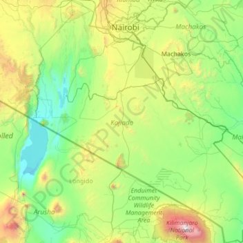
Name: Kajiado County topographic map, elevation, terrain.
Location: Kajiado County, Rift Valley, Kenya (-3.19615 36.00074 -1.04677 37.93793)
Average elevation: 1,408 m
Minimum elevation: 594 m
Maximum elevation: 5,828 m
Other topographic maps
Click on a map to view its topography, its elevation and its terrain.
Nyeri
Nyeri has tarmacked roads, and the county and national governments are upgrading many of them. Houses have drinking water on tap, but sewage provision is through soak pits, pit latrines and septic tanks are still widespread. The city's topography allows nature and gravity to take care of most of the city's…
Average elevation: 1,796 m