
Make a donation
Blue Mountains topographic map
Click on the map to display elevation.
Make a donation
Blue Mountains
A sandstone plateau dominated by a landscape of eucalyptus forests, the Blue Mountains are located at the top of a 470-million-year-old quartzite. In the Permian period, a shallow sea covered the region, when rivers brought shales, siltstones and mudstones. Then during the Mesozoic period, rivers dumped vast amounts of sand, burying the other sedimentary rocks. By about 1 million years ago during the Pliocene era, the Blue Mountains began to form, carving out deep valleys and steep cliffs, with an elevation of 3,900 feet.
Make a donation
About this map
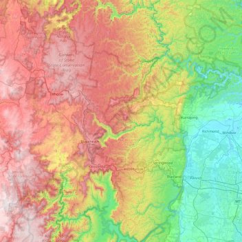
Name: Blue Mountains topographic map, elevation, terrain.
Location: Blue Mountains, New South Wales, Australia (-33.95532 150.12817 -33.17894 150.68710)
Average elevation: 566 m
Minimum elevation: 1 m
Maximum elevation: 1,351 m
Make a donation
Other topographic maps
Click on a map to view its topography, its elevation and its terrain.
Make a donation
Make a donation
Make a donation
Make a donation
Make a donation
Make a donation
Make a donation
Make a donation
Make a donation
Make a donation
Make a donation
Make a donation
Make a donation
Make a donation
Make a donation