
Thank you for supporting this site ❤️
Make a donation
Make a donation
Loureiro topographic map
Click on the map to display elevation.
Thank you for supporting this site ❤️
Make a donation
Make a donation
About this map
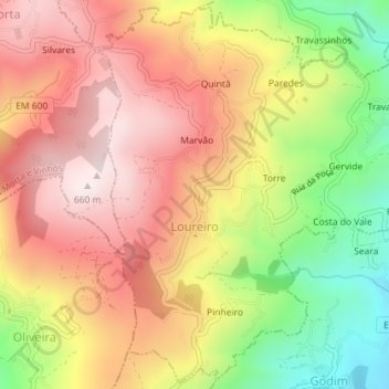
Name: Loureiro topographic map, elevation, terrain.
Location: Loureiro, Peso da Régua, Vila Real, 5050-316, Portugal (41.17129 -7.82428 41.19734 -7.79162)
Average elevation: 409 m
Minimum elevation: 82 m
Maximum elevation: 657 m
Thank you for supporting this site ❤️
Make a donation
Make a donation
Other topographic maps
Click on a map to view its topography, its elevation and its terrain.