
Make a donation
Vrijthout topographic map
Click on the map to display elevation.
Make a donation
About this map
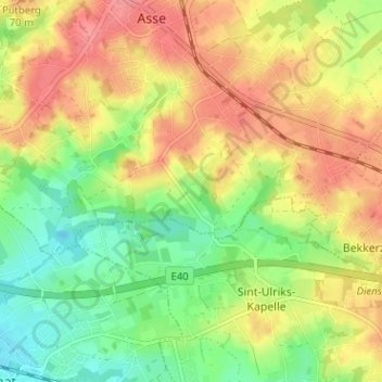
Name: Vrijthout topographic map, elevation, terrain.
Average elevation: 53 m
Minimum elevation: 18 m
Maximum elevation: 86 m
Make a donation
Other topographic maps
Click on a map to view its topography, its elevation and its terrain.
Asse
België > Vlaams-Brabant > Halle-Vilvoorde > Asse
Asse is enigszins verstedelijkt. De hoogte varieert tussen 20 en 85 meter.
Average elevation: 49 m
Mollem
België > Vlaams-Brabant > Halle-Vilvoorde > Asse
Mollem is een deelgemeente van Asse gelegen in de provincie Vlaams-Brabant en het arrondissement Halle-Vilvoorde. Het dorp ligt in het noorden van de Brabantse Zandleemstreek ten noordoosten van de Cuesta van Asse. Traditioneel was Mollem een landbouwgemeente met akkerbouw op de hoogten en weiland in de…
Average elevation: 50 m
Zellik
België > Vlaams-Brabant > Halle-Vilvoorde > Asse
Er was in Zellik een kareelwerk rond de periode 1930, genaamd Briqueterie de Zellick, gelegen aan het hoogtepunt.
Average elevation: 56 m
Kravaalbos
België > Vlaams-Brabant > Halle-Vilvoorde > Asse > Rotten
Het landschap van het bos vertoont duidelijk tekenen van het heuvelland tussen Aalst en Brussel. Zo ligt het hoogste punt om en bij de 80 meter boven zeeniveau, en is er een hoogte-interval van ongeveer 50 meter. Het bos sluit aan op het Natuurpunt-reservaat 'Kravaalvelden' (grasland, hakhoutbos, elzenbroek…
Average elevation: 51 m
Make a donation
Kobbegem
België > Vlaams-Brabant > Halle-Vilvoorde > Asse
Kobbegem ligt op het Brabants Plateau op een hoogte van 47-77 meter.
Average elevation: 62 m