
Brudou topographic map
Interactive map
Click on the map to display elevation.
About this map
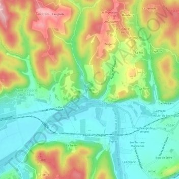
Name: Brudou topographic map, elevation, terrain.
Average elevation: 133 m
Minimum elevation: 55 m
Maximum elevation: 253 m
Other topographic maps
Click on a map to view its topography, its elevation and its terrain.
La Porte
France > Nouvelle-Aquitaine > Dordogne > Beynac-et-Cazenac > Beynac
La Porte, Beynac, Beynac-et-Cazenac, Sarlat-la-Canéda, Dordogne, Nouvelle-Aquitaine, France métropolitaine, 24220, France
Average elevation: 133 m
Château de Beynac
France > Nouvelle-Aquitaine > Dordogne > Beynac-et-Cazenac > Beynac > Brudou
Château de Beynac, Place du Château de Beynac, Brudou, Beynac, Beynac-et-Cazenac, Sarlat-la-Canéda, Dordogne, Nouvelle-Aquitaine, France métropolitaine, 24220, France
Average elevation: 114 m