
Fuilla del Mitg topographic map
Interactive map
Click on the map to display elevation.
About this map
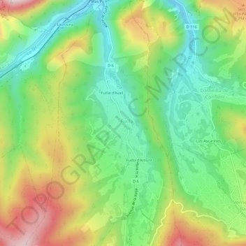
Name: Fuilla del Mitg topographic map, elevation, terrain.
Average elevation: 644 m
Minimum elevation: 455 m
Maximum elevation: 942 m
Other topographic maps
Click on a map to view its topography, its elevation and its terrain.
Fuilla d'Amunt
France > Occitanie > Pyrénées-Orientales > Fuilla
Fuilla d'Amunt, Fuilla, Prades, Pyrénées-Orientales, Occitanie, France métropolitaine, 66820, France
Average elevation: 671 m