
L'Âge-Troinet topographic map
Interactive map
Click on the map to display elevation.
About this map
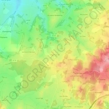
Name: L'Âge-Troinet topographic map, elevation, terrain.
Average elevation: 360 m
Minimum elevation: 292 m
Maximum elevation: 434 m
Other topographic maps
Click on a map to view its topography, its elevation and its terrain.
La Croisière
France > Nouvelle-Aquitaine > Creuse > Saint-Maurice-la-Souterraine
La Croisière, Saint-Maurice-la-Souterraine, Guéret, Creuse, Nouvelle-Aquitaine, France métropolitaine, 23300, France
Average elevation: 355 m