
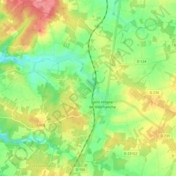
Saint-Hilaire-de-Villefranche topographic map
Interactive map
Click on the map to display elevation.
About this map
Name: Saint-Hilaire-de-Villefranche topographic map, elevation, terrain.
Average elevation: 55 m
Minimum elevation: 20 m
Maximum elevation: 98 m
Other topographic maps
Click on a map to view its topography, its elevation and its terrain.
Chez Dyon
France > Nouvelle-Aquitaine > Charente-Maritime > Saint-Hilaire-de-Villefranche
Chez Dyon, Saint-Hilaire-de-Villefranche, Saint-Jean-d'Angély, Charente-Maritime, Nouvelle-Aquitaine, France métropolitaine, 17770, France
Average elevation: 55 m
Chez Chevroux
France > Nouvelle-Aquitaine > Charente-Maritime > Saint-Hilaire-de-Villefranche
Chez Chevroux, La Frédière, Saint-Hilaire-de-Villefranche, Saint-Jean-d'Angély, Charente-Maritime, Nouvelle-Aquitaine, France métropolitaine, 17770, France
Average elevation: 43 m
Les Ormeaux
France > Nouvelle-Aquitaine > Charente-Maritime > Saint-Hilaire-de-Villefranche
Les Ormeaux, Saint-Hilaire-de-Villefranche, Saint-Jean-d'Angély, Charente-Maritime, Nouvelle-Aquitaine, France métropolitaine, 17770, France
Average elevation: 55 m