
La Morandie topographic map
Interactive map
Click on the map to display elevation.
About this map
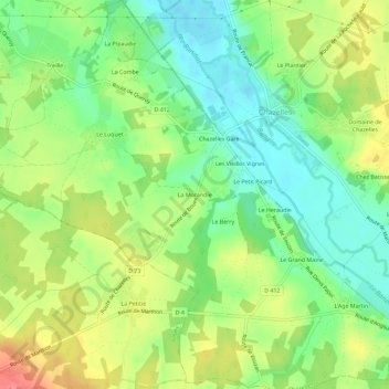
Name: La Morandie topographic map, elevation, terrain.
Average elevation: 114 m
Minimum elevation: 84 m
Maximum elevation: 155 m
Other topographic maps
Click on a map to view its topography, its elevation and its terrain.
Le Plantier
France > Nouvelle-Aquitaine > Charente > Chazelles
Le Plantier, Chazelles, Angoulême, Charente, Nouvelle-Aquitaine, France métropolitaine, 16380, France
Average elevation: 112 m
Les Vieilles Vignes
France > Nouvelle-Aquitaine > Charente > Chazelles
Les Vieilles Vignes, Chazelles, Angoulême, Charente, Nouvelle-Aquitaine, France métropolitaine, 16380, France
Average elevation: 112 m