
Creully topographic map
Interactive map
Click on the map to display elevation.
About this map
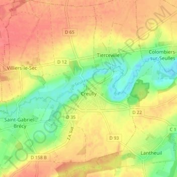
Name: Creully topographic map, elevation, terrain.
Average elevation: 38 m
Minimum elevation: 5 m
Maximum elevation: 65 m
Other topographic maps
Click on a map to view its topography, its elevation and its terrain.
Villiers-le-Sec
France > Normandie > Calvados > Creully sur Seulles
Villiers-le-Sec, Creully sur Seulles, Bayeux, Calvados, Normandie, France métropolitaine, 14480, France
Average elevation: 46 m
Saint-Gabriel-Brécy
France > Normandie > Calvados > Creully sur Seulles
Saint-Gabriel-Brécy, Creully sur Seulles, Bayeux, Calvados, Normandie, France métropolitaine, 14480, France
Average elevation: 40 m