
Aneityum topographic map
Interactive map
Click on the map to display elevation.
About this map
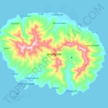
Name: Aneityum topographic map, elevation, terrain.
Location: Aneityum, Tafea, Vanuatu (-20.25239 169.74169 -20.13467 169.90364)
Average elevation: 144 m
Minimum elevation: -1 m
Maximum elevation: 804 m
Other topographic maps
Click on a map to view its topography, its elevation and its terrain.