
Thank you for supporting this site ❤️
Make a donation
Make a donation
Zedelgem topographic map
Click on the map to display elevation.
Thank you for supporting this site ❤️
Make a donation
Make a donation
About this map
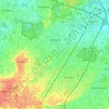
Name: Zedelgem topographic map, elevation, terrain.
Location: Zedelgem, Brugge, West Flanders, Belgium (51.08389 3.05776 51.16737 3.21523)
Average elevation: 16 m
Minimum elevation: 1 m
Maximum elevation: 44 m
Thank you for supporting this site ❤️
Make a donation
Make a donation
Other topographic maps
Click on a map to view its topography, its elevation and its terrain.