
Thank you for supporting this site ❤️
Make a donation
Make a donation
Garkhal topographic map
Click on the map to display elevation.
Thank you for supporting this site ❤️
Make a donation
Make a donation
About this map
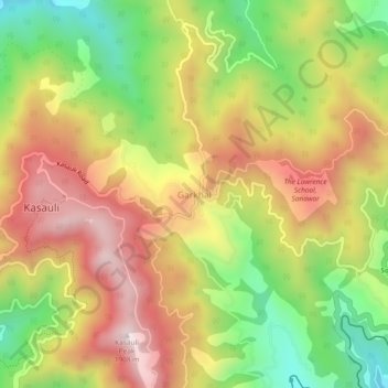
Name: Garkhal topographic map, elevation, terrain.
Location: Garkhal, Kasauli, Solan, Himachal Pradesh, 173209, India (30.88130 76.96037 30.92130 77.00037)
Average elevation: 1,530 m
Minimum elevation: 1,134 m
Maximum elevation: 1,910 m
Thank you for supporting this site ❤️
Make a donation
Make a donation
Other topographic maps
Click on a map to view its topography, its elevation and its terrain.