
Thank you for supporting this site ❤️
Make a donation
Make a donation
Kleinweil topographic map
Click on the map to display elevation.
Thank you for supporting this site ❤️
Make a donation
Make a donation
About this map
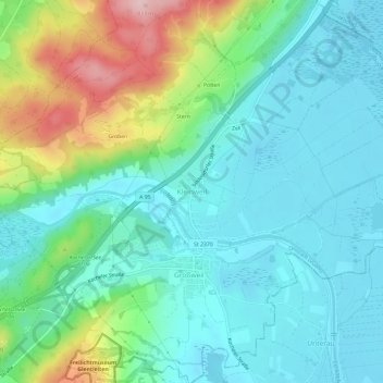
Name: Kleinweil topographic map, elevation, terrain.
Average elevation: 657 m
Minimum elevation: 599 m
Maximum elevation: 828 m
Thank you for supporting this site ❤️
Make a donation
Make a donation
Other topographic maps
Click on a map to view its topography, its elevation and its terrain.
82439
Deutschland > Bayern > Landkreis Garmisch-Partenkirchen > Kleinweil > Zell
Average elevation: 630 m