
Thank you for supporting this site ❤️
Make a donation
Make a donation
Basedow topographic map
Click on the map to display elevation.
Thank you for supporting this site ❤️
Make a donation
Make a donation
Basedow
Im Südwesten des Gemeindegebiets hebt sich das Relief mit dem Basedower Berg auf die Höhenlage von bis zu 47,1 m über Normalhöhennull.
Thank you for supporting this site ❤️
Make a donation
Make a donation
About this map
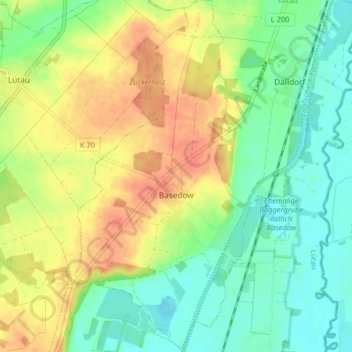
Name: Basedow topographic map, elevation, terrain.
Average elevation: 25 m
Minimum elevation: 4 m
Maximum elevation: 51 m
Thank you for supporting this site ❤️
Make a donation
Make a donation
Other topographic maps
Click on a map to view its topography, its elevation and its terrain.
Rothenhusen
Deutschland > Schleswig-Holstein > Kreis Herzogtum Lauenburg > Groß Sarau
Average elevation: 20 m
Drüsen
Deutschland > Schleswig-Holstein > Kreis Herzogtum Lauenburg > Lehmrade
Average elevation: 40 m
Thank you for supporting this site ❤️
Make a donation
Make a donation
Dalbekschlucht
Deutschland > Schleswig-Holstein > Kreis Herzogtum Lauenburg > Börnsen
Average elevation: 40 m