Davao del Norte topographic map
Interactive map
Click on the map to display elevation.
About this map
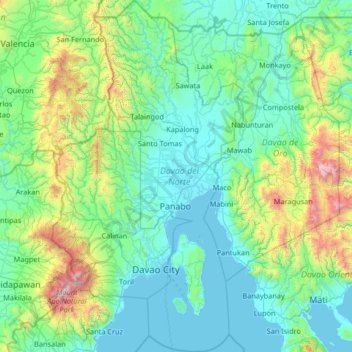
Name: Davao del Norte topographic map, elevation, terrain.
Location: Davao del Norte, Davao Region, Philippines (6.76003 125.39284 7.99940 125.93647)
Average elevation: 408 m
Minimum elevation: 0 m
Maximum elevation: 2,842 m
Other topographic maps
Click on a map to view its topography, its elevation and its terrain.
Tagum
One of the significant accomplishments of the officialdom of Tagum during the 1990s was its elevation from a second to the first-class municipality. This opened a gateway to increase its financial resources through the Internal Revenue Allocation (IRA) from the national government and local revenues. This was…
Average elevation: 91 m