
Lotissement Les Boutères topographic map
Interactive map
Click on the map to display elevation.
About this map
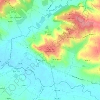
Name: Lotissement Les Boutères topographic map, elevation, terrain.
Average elevation: 55 m
Minimum elevation: 26 m
Maximum elevation: 117 m
Other topographic maps
Click on a map to view its topography, its elevation and its terrain.
La Fonpeyre
France > Nouvelle-Aquitaine > Lot-et-Garonne > Duras > La Fonpeyre
La Fonpeyre, Duras, Marmande, Lot-et-Garonne, Nouvelle-Aquitaine, France métropolitaine, 47120, France
Average elevation: 55 m