
Erkner topographic map
Interactive map
Click on the map to display elevation.
About this map
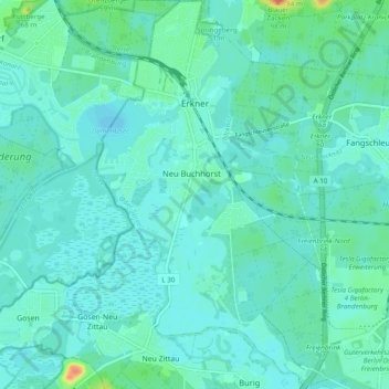
Name: Erkner topographic map, elevation, terrain.
Location: Erkner, Oder-Spree, Brandenburg, Deutschland (52.38257 13.72281 52.44161 13.79150)
Average elevation: 39 m
Minimum elevation: 30 m
Maximum elevation: 82 m
Zu Erkner gehören die Wohnplätze Alte Hausstelle, Heim Gottesschutz, Hohenbinde, Jägerbude, Karutzhöhe, Neu Buchhorst, Neuseeland, Schönschornstein und Spreeeck.
Other topographic maps
Click on a map to view its topography, its elevation and its terrain.
Woltersdorf
Deutschland > Brandenburg > Oder-Spree
Woltersdorf, Oder-Spree, Brandenburg, 15569, Deutschland
Average elevation: 49 m
Scharmützelsee
Deutschland > Brandenburg > Oder-Spree > Bad Saarow
Scharmützelsee, Bad Saarow, Scharmützelsee, Oder-Spree, Brandenburg, Deutschland
Average elevation: 65 m