
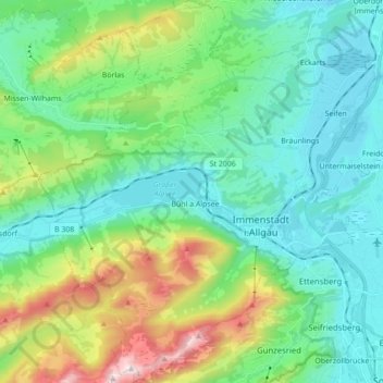
Immenstadt im Allgäu topographic map
Interactive map
Click on the map to display elevation.
About this map
Name: Immenstadt im Allgäu topographic map, elevation, terrain.
Average elevation: 918 m
Minimum elevation: 697 m
Maximum elevation: 1,731 m
Other topographic maps
Click on a map to view its topography, its elevation and its terrain.
Bischlags
Germany > Bavaria > Landkreis Oberallgäu > Seebach
Bischlags, Seebach, Haldenwang, Landkreis Oberallgäu, Bavaria, 87490, Germany
Average elevation: 740 m
Blaichach
Germany > Bavaria > Landkreis Oberallgäu
Blaichach, Landkreis Oberallgäu, Bavaria, 87544, Germany
Average elevation: 1,003 m
Ellensberg
Germany > Bavaria > Landkreis Oberallgäu > Lauben
Ellensberg, Lauben, Landkreis Oberallgäu, Bavaria, Germany
Average elevation: 673 m