
Thank you for supporting this site ❤️
Make a donation
Make a donation
Quinta do Conde topographic map
Click on the map to display elevation.
Thank you for supporting this site ❤️
Make a donation
Make a donation
About this map
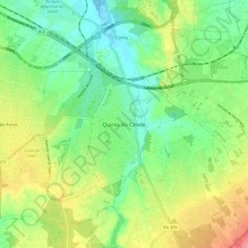
Name: Quinta do Conde topographic map, elevation, terrain.
Location: Quinta do Conde, Sesimbra, Setúbal, 2975-333, Portugal (38.52552 -9.08122 38.60552 -9.00122)
Average elevation: 49 m
Minimum elevation: -1 m
Maximum elevation: 135 m
Thank you for supporting this site ❤️
Make a donation
Make a donation
Other topographic maps
Click on a map to view its topography, its elevation and its terrain.
Thank you for supporting this site ❤️
Make a donation
Make a donation
Almada, Cova da Piedade, Pragal e Cacilhas
Portugal > Setúbal > Almada > Monte de Caparica
Average elevation: 30 m
Thank you for supporting this site ❤️
Make a donation
Make a donation
Thank you for supporting this site ❤️
Make a donation
Make a donation
Thank you for supporting this site ❤️
Make a donation
Make a donation