
Thank you for supporting this site ❤️
Make a donation
Make a donation
Raymond topographic map
Click on the map to display elevation.
Thank you for supporting this site ❤️
Make a donation
Make a donation
About this map
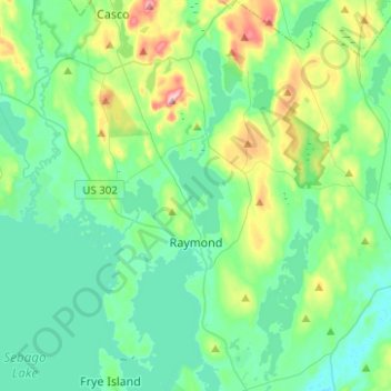
Name: Raymond topographic map, elevation, terrain.
Location: Raymond, Cumberland County, Maine, 04071, United States (43.83335 -70.54331 44.01281 -70.37450)
Average elevation: 114 m
Minimum elevation: 61 m
Maximum elevation: 308 m
Thank you for supporting this site ❤️
Make a donation
Make a donation
Other topographic maps
Click on a map to view its topography, its elevation and its terrain.
Thank you for supporting this site ❤️
Make a donation
Make a donation
Littlejohn Island
United States > Maine > Cumberland County > Yarmouth > Cousins Island
Average elevation: 5 m
Thank you for supporting this site ❤️
Make a donation
Make a donation