
Make a donation
Hohenwarsleben topographic map
Click on the map to display elevation.
Make a donation
About this map
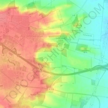
Name: Hohenwarsleben topographic map, elevation, terrain.
Location: Hohenwarsleben, Hohe Börde, Börde, Sachsen-Anhalt, Deutschland (52.15505 11.48486 52.18809 11.54273)
Average elevation: 106 m
Minimum elevation: 64 m
Maximum elevation: 142 m
Make a donation
Other topographic maps
Click on a map to view its topography, its elevation and its terrain.
Stadt Frankfurt
Deutschland > Sachsen-Anhalt > Börde > Wanzleben-Börde
Die kleine Siedlung in der Magdeburger Börde hat 35 Einwohner (Stand 2008) und liegt südwestlich von Wanzleben, südlich der von Oschersleben nach Wanzleben führenden Bundesstraße 246. In der Nähe befindet sich eine kleine Erhebung mit einer Höhe von 113 Metern. Nördlich von Stadt Frankfurt stehen die…
Average elevation: 104 m
Make a donation
Kloster Gröningen
Deutschland > Sachsen-Anhalt > Börde > Gröningen
Die Klosterkirche St. Vitus, auf einer leichten Anhöhe liegend, wurde 940 von Abt Volkmar I. aus Corvey geweiht. Vom Anfang bis etwa Mitte des 12. Jahrhunderts wurde die heutige Kirche als romanische dreischiffige Flachdeckenbasilika im Hirsauer Baustil neu erbaut. Das Patrozinium erhielt der heilige Vitus…
Average elevation: 95 m
Make a donation
Make a donation
Osterweddingen
Deutschland > Sachsen-Anhalt > Börde > Sülzetal > Osterweddingen
Average elevation: 78 m
Make a donation