
Thank you for supporting this site ❤️
Make a donation
Make a donation
Avondale topographic map
Click on the map to display elevation.
Thank you for supporting this site ❤️
Make a donation
Make a donation
About this map
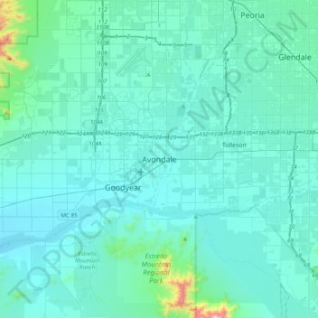
Name: Avondale topographic map, elevation, terrain.
Location: Avondale, Maricopa County, Arizona, 85323, United States (33.27560 -112.50960 33.59560 -112.18960)
Average elevation: 340 m
Minimum elevation: 257 m
Maximum elevation: 1,279 m
Thank you for supporting this site ❤️
Make a donation
Make a donation
Other topographic maps
Click on a map to view its topography, its elevation and its terrain.
Estrella Mountain Regional Park
United States > Arizona > Maricopa County > Avondale
Average elevation: 397 m