
Grimaud topographic map
Interactive map
Click on the map to display elevation.
About this map
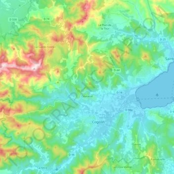
Name: Grimaud topographic map, elevation, terrain.
Average elevation: 151 m
Minimum elevation: 0 m
Maximum elevation: 629 m
Other topographic maps
Click on a map to view its topography, its elevation and its terrain.
Les Hautes Mûres
Frankrijk > Provence-Alpes-Côte d'Azur > Var > Grimaud > Les Hautes Mûres
Les Hautes Mûres, Grimaud, Draguignan, Var, Provence-Alpes-Côte d'Azur, Metropolitaans Frankrijk, 83310, Frankrijk
Average elevation: 108 m