
Gahan topographic map
Interactive map
Click on the map to display elevation.
About this map
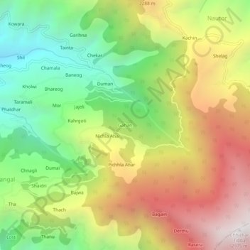
Name: Gahan topographic map, elevation, terrain.
Location: Gahan, Kumharsain, Shimla District, Himachal Pradesh, India (31.26377 77.36306 31.30377 77.40306)
Average elevation: 1,930 m
Minimum elevation: 1,077 m
Maximum elevation: 2,937 m
Other topographic maps
Click on a map to view its topography, its elevation and its terrain.
Bai
India > Himachal Pradesh > Kumharsain > Kumharsain
Bai, Kumharsain, Shimla District, Himachal Pradesh, 172029, India
Average elevation: 1,537 m
Narkanda
India > Himachal Pradesh > Kumharsain
Narkanda, Kumharsain, Shimla District, Himachal Pradesh, 171213, India
Average elevation: 2,466 m
Sowari
India > Himachal Pradesh > Kumharsain
Sowari, Kumharsain, Shimla District, Himachal Pradesh, 172031, India
Average elevation: 1,841 m