
Merkle Wildlife Sanctuary Natural Resource Management Area topographic map
Interactive map
Click on the map to display elevation.
About this map
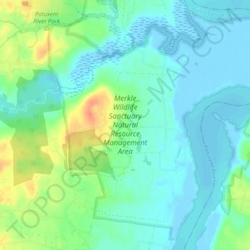
Name: Merkle Wildlife Sanctuary Natural Resource Management Area topographic map, elevation, terrain.
Average elevation: 13 m
Minimum elevation: -5 m
Maximum elevation: 44 m
Other topographic maps
Click on a map to view its topography, its elevation and its terrain.
Rosaryville State Park
United States > Maryland > Prince George's County > Upper Marlboro
Rosaryville State Park, 7805, Upper Marlboro, Prince George's County, Maryland, 20735, United States
Average elevation: 59 m