
North Brentwood topographic map
Interactive map
Click on the map to display elevation.
About this map
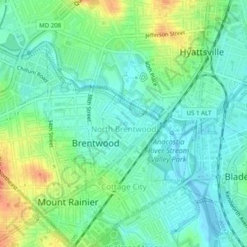
Name: North Brentwood topographic map, elevation, terrain.
Average elevation: 15 m
Minimum elevation: -2 m
Maximum elevation: 46 m
Other topographic maps
Click on a map to view its topography, its elevation and its terrain.
Hyattsville
United States > Maryland > Prince George's County
Hyattsville, Prince George's County, Maryland, 20781, United States
Average elevation: 61 m
College Park
United States > Maryland > Prince George's County
College Park, Prince George's County, Maryland, United States
Average elevation: 38 m
Cottage City
United States > Maryland > Prince George's County
Cottage City, Prince George's County, Maryland, United States
Average elevation: 17 m
Dinosaur Park
United States > Maryland > Prince George's County > South Laurel > Montpelier Forest
Dinosaur Park, Montpelier Forest, South Laurel, Prince George's County, Maryland, 20708, United States
Average elevation: 67 m
Ammendale
United States > Maryland > Prince George's County > Konterra
Ammendale, Konterra, Prince George's County, Maryland, 20705, United States
Average elevation: 56 m
North Keys
United States > Maryland > Prince George's County
North Keys, Prince George's County, Maryland, United States
Average elevation: 43 m
Landover
United States > Maryland > Prince George's County > Landover
Landover, Prince George's County, Maryland, 20785, United States
Average elevation: 38 m
Hyattsville
United States > Maryland > Prince George's County
Hyattsville, Prince George's County, Maryland, 20782, United States
Average elevation: 24 m
Queenland
United States > Maryland > Prince George's County > Mellwood
Queenland, Mellwood, Prince George's County, Maryland, 20772, United States
Average elevation: 42 m
Cedarville
United States > Maryland > Prince George's County
Cedarville, Prince George's County, Maryland, United States
Average elevation: 63 m
Westphalia
United States > Maryland > Prince George's County
Westphalia, Prince George's County, Maryland, United States
Average elevation: 62 m
Glassmanor
United States > Maryland > Prince George's County > Glassmanor
Glassmanor, Prince George's County, Maryland, United States
Average elevation: 53 m
Colmar Manor
United States > Maryland > Prince George's County
Colmar Manor, Prince George's County, Maryland, United States
Average elevation: 18 m
Lake Arbor
United States > Maryland > Prince George's County > Lake Arbor
Lake Arbor, Prince George's County, Maryland, United States
Average elevation: 46 m
Landover Hills
United States > Maryland > Prince George's County
Landover Hills, Prince George's County, Maryland, United States
Average elevation: 41 m
Capitol Heights
United States > Maryland > Prince George's County
Capitol Heights, Prince George's County, Maryland, United States
Average elevation: 64 m
Fort Washington
United States > Maryland > Prince George's County > Fort Washington
Fort Washington, Prince George's County, Maryland, United States
Average elevation: 29 m
Phelps Corner
United States > Maryland > Prince George's County > Oxon Hill
Phelps Corner, Oxon Hill, Prince George's County, Maryland, 20745, United States
Average elevation: 58 m
Clinton
United States > Maryland > Prince George's County
Clinton, Prince George's County, Maryland, 20735, United States
Average elevation: 64 m
Upper Marlboro
United States > Maryland > Prince George's County
Upper Marlboro, Prince George's County, Maryland, United States
Average elevation: 22 m
Overbrook
United States > Maryland > Prince George's County > Bowie
Overbrook, Bowie, Prince George's County, Maryland, 20715, United States
Average elevation: 32 m
Glenn Dale
United States > Maryland > Prince George's County > Glenn Dale
Glenn Dale, Prince George's County, Maryland, United States
Average elevation: 52 m
District Heights
United States > Maryland > Prince George's County > District Heights
District Heights, Prince George's County, Maryland, 20747, United States
Average elevation: 77 m
Bowie
United States > Maryland > Prince George's County > Bowie
Bowie, Prince George's County, Maryland, United States
Average elevation: 38 m
Adelphi
United States > Maryland > Prince George's County > Adelphi
Adelphi, Prince George's County, Maryland, United States
Average elevation: 56 m
Mount Rainier
United States > Maryland > Prince George's County
Mount Rainier, Prince George's County, Maryland, 20712, United States
Average elevation: 20 m
Laurel
United States > Maryland > Prince George's County
Laurel, Prince George's County, Maryland, 20707, United States
Average elevation: 73 m
Edmonston
United States > Maryland > Prince George's County
Edmonston, Prince George's County, Maryland, 20781, United States
Average elevation: 21 m
Riverdale Park
United States > Maryland > Prince George's County
Riverdale Park, Prince George's County, Maryland, United States
Average elevation: 23 m