
Thank you for supporting this site ❤️
Make a donation
Make a donation
Hayward topographic map
Click on the map to display elevation.
Thank you for supporting this site ❤️
Make a donation
Make a donation
About this map
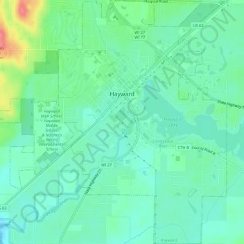
Name: Hayward topographic map, elevation, terrain.
Location: Hayward, Sawyer County, Wisconsin, United States (45.99032 -91.51435 46.02703 -91.46219)
Average elevation: 367 m
Minimum elevation: 348 m
Maximum elevation: 418 m
Thank you for supporting this site ❤️
Make a donation
Make a donation
Other topographic maps
Click on a map to view its topography, its elevation and its terrain.