
Thank you for supporting this site ❤️
Make a donation
Make a donation
Bonnert topographic map
Click on the map to display elevation.
Thank you for supporting this site ❤️
Make a donation
Make a donation
About this map
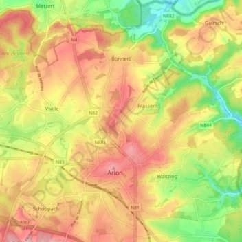
Name: Bonnert topographic map, elevation, terrain.
Location: Bonnert, Arlon, Luxembourg, Wallonie, Belgique (49.67056 5.77793 49.72096 5.86750)
Average elevation: 373 m
Minimum elevation: 293 m
Maximum elevation: 438 m
Thank you for supporting this site ❤️
Make a donation
Make a donation
Other topographic maps
Click on a map to view its topography, its elevation and its terrain.
Thank you for supporting this site ❤️
Make a donation
Make a donation
Autelbas-Barnich
Belgique > Luxembourg > Arlon > Arlon
L’altitude à Autelbas-Barnich est d’environ 330 m.
Average elevation: 336 m