
Fairborn topographic map
Click on the map to display elevation.
About this map
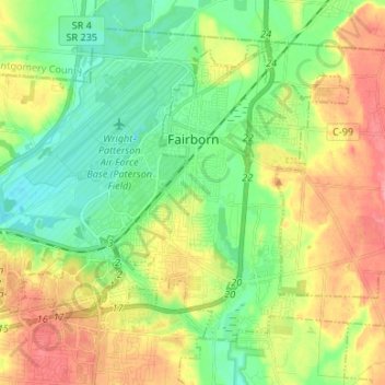
Name: Fairborn topographic map, elevation, terrain.
Location: Fairborn, Greene County, Ohio, United States (39.76724 -84.07915 39.84597 -83.94604)
Average elevation: 272 m
Minimum elevation: 238 m
Maximum elevation: 322 m
Other topographic maps
Click on a map to view its topography, its elevation and its terrain.
John Bryan State Park
United States > Ohio > Greene County > Yellow Springs > Clifton
Average elevation: 309 m