
Thank you for supporting this site ❤️
Make a donation
Make a donation
Fajão topographic map
Click on the map to display elevation.
Thank you for supporting this site ❤️
Make a donation
Make a donation
About this map
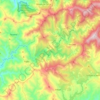
Name: Fajão topographic map, elevation, terrain.
Location: Fajão, Pampilhosa da Serra, Coimbra, Portugal (40.11733 -7.97765 40.21090 -7.80808)
Average elevation: 790 m
Minimum elevation: 341 m
Maximum elevation: 1,410 m
Thank you for supporting this site ❤️
Make a donation
Make a donation
Other topographic maps
Click on a map to view its topography, its elevation and its terrain.
Thank you for supporting this site ❤️
Make a donation
Make a donation
Thank you for supporting this site ❤️
Make a donation
Make a donation
Thank you for supporting this site ❤️
Make a donation
Make a donation
Thank you for supporting this site ❤️
Make a donation
Make a donation
Thank you for supporting this site ❤️
Make a donation
Make a donation