
Thank you for supporting this site ❤️
Make a donation
Make a donation
South Fork topographic map
Click on the map to display elevation.
Thank you for supporting this site ❤️
Make a donation
Make a donation
About this map
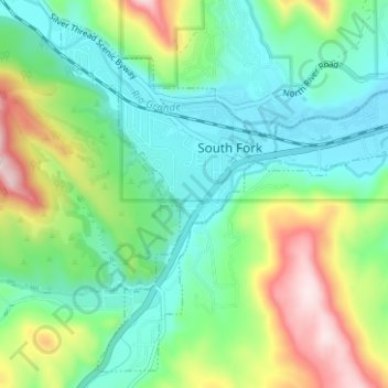
Name: South Fork topographic map, elevation, terrain.
Location: South Fork, Rio Grande County, Colorado, United States (37.64228 -106.66981 37.68746 -106.60717)
Average elevation: 2,617 m
Minimum elevation: 2,488 m
Maximum elevation: 2,913 m
Thank you for supporting this site ❤️
Make a donation
Make a donation
Other topographic maps
Click on a map to view its topography, its elevation and its terrain.
Del Norte
United States > Colorado > Rio Grande County
Del Norte's absolute location is at 37°40′44″N 106°21′11″W / 37.67889°N 106.35306°W / 37.67889; -106.35306 (37.679015, -106.352976). Relatively-speaking, it is located where the Rio Grande leaves the San Juan Mountains and enters the San Luis Valley, near its confluences with Pinos Creek…
Average elevation: 2,416 m