
Thank you for supporting this site ❤️
Make a donation
Make a donation
Victoria Harbour topographic map
Click on the map to display elevation.
Thank you for supporting this site ❤️
Make a donation
Make a donation
About this map
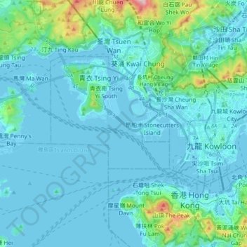
Name: Victoria Harbour topographic map, elevation, terrain.
Average elevation: 74 m
Minimum elevation: -20 m
Maximum elevation: 667 m
Thank you for supporting this site ❤️
Make a donation
Make a donation
Other topographic maps
Click on a map to view its topography, its elevation and its terrain.
Kwai Chung Tai Hang Mei Tsuen
China > Hong Kong > Kwai Tsing District > Kwai Chung
Average elevation: 176 m