
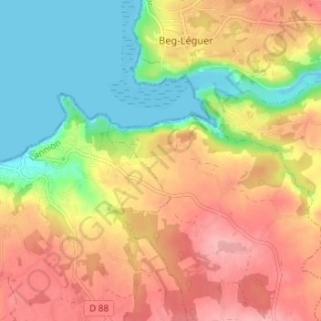
Lann Kerallic topographic map
Interactive map
Click on the map to display elevation.
About this map
Name: Lann Kerallic topographic map, elevation, terrain.
Average elevation: 56 m
Minimum elevation: -7 m
Maximum elevation: 108 m
Other topographic maps
Click on a map to view its topography, its elevation and its terrain.
Lotissement Tallegas
France > Bretagne > Côtes-d'Armor > Ploumilliau
Lotissement Tallegas, Ploumilliau, Lannion, Côtes-d'Armor, Bretagne, France métropolitaine, 22300, France
Average elevation: 101 m
Pont Rous
France > Bretagne > Côtes-d'Armor > Ploumilliau
Pont Rous, Ploumilliau, Lannion, Côtes-d'Armor, Bretagne, France métropolitaine, 22300, France
Average elevation: 57 m
Toull Karr
France > Bretagne > Côtes-d'Armor > Ploumilliau
Toull Karr, Ploumilliau, Lannion, Côtes-d'Armor, Bretagne, France métropolitaine, 22300, France
Average elevation: 97 m
Ponchou-Meïn
France > Bretagne > Côtes-d'Armor > Ploumilliau
Ponchou-Meïn, Ploumilliau, Lannion, Côtes-d'Armor, Bretagne, France métropolitaine, 22300, France
Average elevation: 85 m