
La Cassière topographic map
Interactive map
Click on the map to display elevation.
About this map
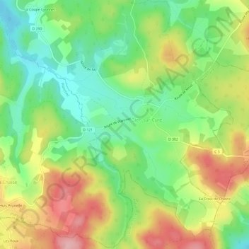
Name: La Cassière topographic map, elevation, terrain.
Average elevation: 655 m
Minimum elevation: 591 m
Maximum elevation: 738 m
Other topographic maps
Click on a map to view its topography, its elevation and its terrain.
La Coupe Lyonnet
France > Bourgogne-Franche-Comté > Nièvre > Gien-sur-Cure
La Coupe Lyonnet, Gien-sur-Cure, Château-Chinon (Ville), Nièvre, Bourgogne-Franche-Comté, France métropolitaine, 58230, France
Average elevation: 634 m