
Make a donation
Lebanon topographic map
Click on the map to display elevation.
Make a donation
Lebanon
According to the United States Census Bureau, the town has a total area of 55.83 square miles (144.60 km2), of which 55.00 square miles (142.45 km2) is land and 0.83 square miles (2.15 km2) is water. Lebanon is drained by the Little River and Salmon Falls River. The town's highest point is Prospect Hill, at an elevation of 880 feet (268 m) above sea level. The lowest elevation borders the Salmon Falls River, on the town's southernmost boundary, which is approximately 170 feet (52 m) above sea level.
Make a donation
About this map
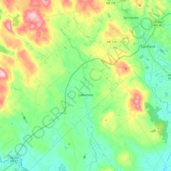
Name: Lebanon topographic map, elevation, terrain.
Location: Lebanon, York County, Maine, 04027, United States (43.32569 -70.98843 43.48059 -70.81347)
Average elevation: 121 m
Minimum elevation: 51 m
Maximum elevation: 267 m
Make a donation
Other topographic maps
Click on a map to view its topography, its elevation and its terrain.
Make a donation
Make a donation