
Mendenhall Glacier topographic map
Interactive map
Click on the map to display elevation.
About this map
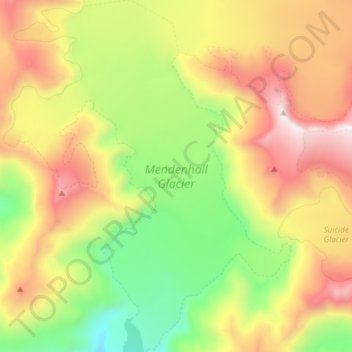
Name: Mendenhall Glacier topographic map, elevation, terrain.
Location: Mendenhall Glacier, Juneau, Alaska, United States (58.43765 -134.60510 58.51645 -134.48199)
Average elevation: 875 m
Minimum elevation: 157 m
Maximum elevation: 1,789 m
Other topographic maps
Click on a map to view its topography, its elevation and its terrain.
Mount Ogden
United States > Alaska > Juneau
Mount Ogden, Juneau, Alaska, United States
Average elevation: 1,702 m
Mount Juneau
United States > Alaska > Juneau
Mount Juneau, Juneau, Alaska, 99802, United States
Average elevation: 595 m