
Kajang Municipal Council topographic map
Interactive map
Click on the map to display elevation.
About this map
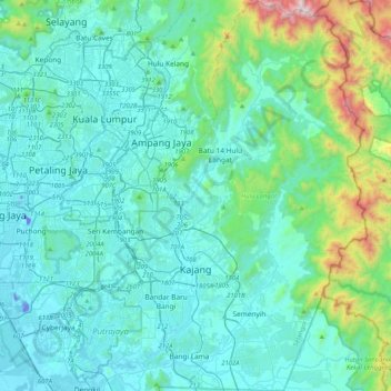
Name: Kajang Municipal Council topographic map, elevation, terrain.
Location: Kajang Municipal Council, Hulu Langat, Selangor, Malaysia (2.86610 101.72088 3.27580 101.96981)
Average elevation: 198 m
Minimum elevation: -27 m
Maximum elevation: 1,435 m
Other topographic maps
Click on a map to view its topography, its elevation and its terrain.
Sungai Long
Malaysia > Selangor > Kajang Municipal Council
Sungai Long, Kajang Municipal Council, Hulu Langat, Selangor, 43100, Malaysia
Average elevation: 123 m
Bukit Beruntung
Malaysia > Selangor > Bukit Beruntung
Bukit Beruntung, Hulu Selangor, Selangor, 48300, Malaysia
Average elevation: 56 m
Kampung Atap
Malaysia > Selangor > Klang Municipal Council > Kampung Atap
Kampung Atap, Klang Municipal Council, Klang, Selangor, 41400, Malaysia
Average elevation: 7 m
Klang Municipal Council
Malaysia > Selangor > Klang Municipal Council
Klang Municipal Council, Selangor, Malaysia
Average elevation: 12 m
Kapar
Malaysia > Selangor > Klang Municipal Council > Kapar
Kapar, Klang Municipal Council, Selangor, 42200, Malaysia
Average elevation: 5 m
Subang Jaya City Council
Malaysia > Selangor > Subang Jaya City Council
Subang Jaya City Council, Selangor, Malaysia
Average elevation: 28 m
Section 19
Malaysia > Selangor > SA > Section 19
Section 19, SA, Selangor, 40200, Malaysia
Average elevation: 10 m