
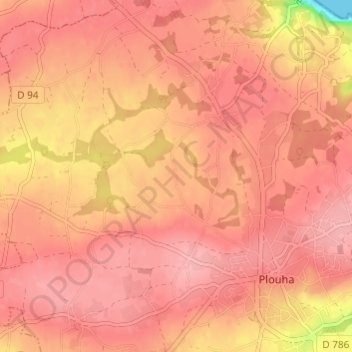
Crec'h Huel topographic map
Interactive map
Click on the map to display elevation.
About this map
Name: Crec'h Huel topographic map, elevation, terrain.
Average elevation: 83 m
Minimum elevation: 0 m
Maximum elevation: 107 m
Other topographic maps
Click on a map to view its topography, its elevation and its terrain.
Vieux Bréhec
France > Bretagne > Côtes-d'Armor > Plouha
Vieux Bréhec, Plouha, Guingamp, Côtes-d'Armor, Bretagne, France métropolitaine, 22580, France
Average elevation: 55 m
Kerouziel
France > Bretagne > Côtes-d'Armor > Plouha
Kerouziel, Plouha, Guingamp, Côtes-d'Armor, Bretagne, France métropolitaine, 22580, France
Average elevation: 38 m
Le Palus
France > Bretagne > Côtes-d'Armor > Plouha
Le Palus, Plouha, Guingamp, Côtes-d'Armor, Bretagne, France métropolitaine, 22580, France
Average elevation: 49 m
Kerlevenez
France > Bretagne > Côtes-d'Armor > Plouha
Kerlevenez, Plouha, Guingamp, Côtes-d'Armor, Bretagne, France métropolitaine, 22580, France
Average elevation: 62 m
Kerlévé
France > Bretagne > Côtes-d'Armor > Plouha
Kerlévé, Plouha, Guingamp, Côtes-d'Armor, Bretagne, France métropolitaine, 22580, France
Average elevation: 82 m