
Thank you for supporting this site ❤️
Make a donation
Make a donation
Pamel topographic map
Click on the map to display elevation.
Thank you for supporting this site ❤️
Make a donation
Make a donation
About this map
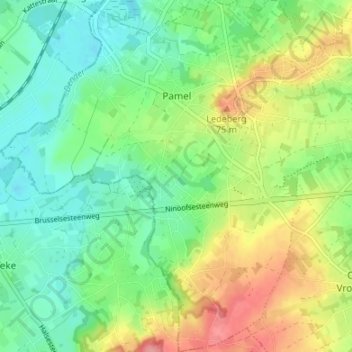
Name: Pamel topographic map, elevation, terrain.
Location: Pamel, Roosdaal, Halle-Vilvoorde, Flemish Brabant, 1760, Belgium (50.81353 4.04067 50.85591 4.10169)
Average elevation: 40 m
Minimum elevation: 5 m
Maximum elevation: 100 m
Thank you for supporting this site ❤️
Make a donation
Make a donation
Other topographic maps
Click on a map to view its topography, its elevation and its terrain.
Thank you for supporting this site ❤️
Make a donation
Make a donation
Thank you for supporting this site ❤️
Make a donation
Make a donation