Geolocate

Springfield Township topographic map

Click on the map to display elevation.

About this map

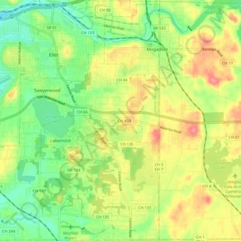
Name: Springfield Township topographic map, elevation, terrain.

Location: Springfield Township, Summit County, Ohio, United States (40.98815 -81.49237 41.06677 -81.39296)

Average elevation: 343 m

Minimum elevation: 308 m

Maximum elevation: 385 m

Other topographic maps

Click on a map to view its topography, its elevation and its terrain.

Metz

United States > Ohio > Summit County > Stow

Average elevation: 318 m

Sagamore Hills

United States > Ohio > Summit County

Average elevation: 264 m

Maple Grove Park

United States > Ohio > Summit County > Hudson

Average elevation: 316 m

Copley

United States > Ohio > Summit County

Average elevation: 318 m

Boston

United States > Ohio > Summit County

Average elevation: 245 m

Myersville

United States > Ohio > Summit County > Green

Average elevation: 342 m

Decker Park

United States > Ohio > Summit County > Barberton

Average elevation: 304 m

Metz

United States > Ohio > Summit County > Stow

Average elevation: 318 m