Geolocate

Chubut Province topographic map

Interactive map

Click on the map to display elevation.

Chubut Province

Chubut stretches from the Atlantic to the Andes with 3 distinct environmental regions: The Andes, the central plains and the coastal regions. The Andes in the westernmost parts of the province mostly extend along the Chilean border. The Andes are not that high in Chubut, with most peaks averaging around 1,500 and 2,000 metres (4,900 and 6,600 ft), which becomes smaller in altitude in the southern parts. The highest peak is Cerro Dos Picos, located east of Lago Cholila with a height of 2,515 metres (8,251 ft). The Andes in this province are of tertiary origin and are separated by wide, deep transverse valleys that are oriented in an east–west direction. These valleys are occupied by glacial lakes and rivers flowing east from the mountains. Most of these valleys existed before the Andes were formed. The lakes, which are mostly located in the western parts of the province are of glacial origin because during the last ice age, the movement of the glaciers lead to the formation of extensive areas of depressions that were filled up with water to form the lakes today.

Wikipedia (CC-BY-SA 3.0)

About this map

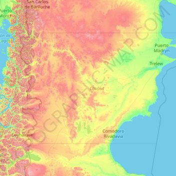
Name: Chubut Province topographic map, elevation, terrain.

Location: Chubut Province, Argentina (-46.00002 -72.18782 -41.99203 -63.31159)

Average elevation: 556 m

Minimum elevation: 0 m

Maximum elevation: 3,110 m

Other topographic maps

Click on a map to view its topography, its elevation and its terrain.

Río Negro Province

Argentina

The climate of the province is temperate at low elevations, and very cold in the higher Andean peaks.

Average elevation: 621 m

Pilar

Argentina > Buenos Aires

Average elevation: 19 m

Entre Ríos Province

Argentina

Average elevation: 53 m

Neuquén Province

Argentina

Mean temperatures are relatively cold for its latitude due to the high altitude. The warmest region is the eastern parts of the province where mean annual temperatures range from 13 to 15 °C (55.4 to 59.0 °F). The coldest areas are located in the Andean region where mean annual temperatures are below 5 °C…

Average elevation: 809 m

Tierra del Fuego Province

Argentina

Average elevation: 135 m

Rosario

Argentina > Santa Fe > Rosario

Average elevation: 20 m

Posadas

Argentina > Misiones > Posadas

Average elevation: 110 m

Capital

Argentina > San Juan

Average elevation: 646 m

Pedanía Castaño

Argentina > Córdoba

Average elevation: 99 m

Cordoba

Argentina > Córdoba > Cordoba

Average elevation: 440 m

Funes

Argentina > Santa Fe > Funes

Average elevation: 31 m

Colonia San Jorge

Argentina > TU > Colonia San Jorge

Average elevation: 393 m

La Amalia

Argentina > Buenos Aires

Average elevation: 66 m

Mirador

Argentina > SC > Mirador

Average elevation: 45 m

Garín

Argentina > Buenos Aires > Garín

Average elevation: 17 m

María Goretti

Argentina > RN

Average elevation: 258 m

Salta

Argentina > SA > Salta

Average elevation: 1,270 m

Mar del Plata

Argentina > Buenos Aires > Mar del Plata

Average elevation: 17 m

Olavarría

Argentina > Buenos Aires > Olavarría

Average elevation: 167 m

Santa Anita

Argentina > Buenos Aires > San Miguel

Average elevation: 31 m

Santa Cruz Province

Argentina

From the centre to the Atlantic coast in the east, the landscape is dominated by plateaus. These plateaus are made up of basalt rock occur in stepped sequences. The plateaus are of different ages with the older –of Neogene and Paleogene age– being located at higher elevations than Pleistocene and Holocene…

Average elevation: 350 m

Mendoza

Argentina > Mza. > Mendoza

Average elevation: 813 m

Nahuel Huapi National Park

Argentina > NQN

Average elevation: 1,061 m

San Martín

Argentina > SC > Río Gallegos

Average elevation: 14 m

Quebrada de las Rosas

Argentina > Córdoba > Cordoba

Average elevation: 447 m

Los Alerces National Park

Argentina > CHB

Average elevation: 1,074 m

Cerro Aconcagua

Argentina > Mza.

Average elevation: 6,197 m

Dique Las Maderas

Argentina > JJY

Average elevation: 1,189 m

La Paloma

Argentina > SC

Average elevation: 141 m

Resistencia

Argentina > CCO > Resistencia

Average elevation: 51 m

CCO

Argentina > CCO

Average elevation: 124 m

Monte Pissis

Argentina > CTM

Average elevation: 6,465 m

Zona 2

Argentina > Santa Fe > Funes

Average elevation: 34 m

Nissi

Argentina > Mnes. > Posadas

Average elevation: 130 m