Geolocate

Gyeonggi topographic map

Interactive map

Click on the map to display elevation.

About this map

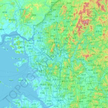
Name: Gyeonggi topographic map, elevation, terrain.

Location: Gyeonggi, South Korea (36.89339 126.27795 38.28111 127.84811)

Average elevation: 136 m

Minimum elevation: -3 m

Maximum elevation: 1,431 m

The topography of Gyeonggi-do is divided into southern and northern areas by the Han River, which flows from east to west. The area north to the Han River is mainly mountainous, while the southern area is mainly plain.

Wikipedia (CC-BY-SA 3.0)

Other topographic maps

Click on a map to view its topography, its elevation and its terrain.

Incheon

South Korea

Incheon, South Korea

Average elevation: 114 m

Seoul

South Korea > Seoul

Seoul, South Korea

Average elevation: 80 m

Gyeonggi

South Korea > Gyeonggi-do > Suwon-si > Gyo-dong

Gyeonggi, Paldalsan-ro, Gyo-dong, Paldal-gu, Suwon-si, Gyeonggi-do, 16251, South Korea

Average elevation: 53 m

Bora-dong

South Korea > Gyeonggi-do > Yongin-si > Giheung-gu > Bora-dong

Bora-dong, Giheung-gu, Yongin-si, Gyeonggi-do, 17080, South Korea

Average elevation: 92 m

Gunpo-si

South Korea > Gyeonggi-do

Gunpo-si, Gyeonggi-do, South Korea

Average elevation: 102 m

Busan

South Korea

Busan, South Korea

Average elevation: 40 m