
Make a donation
Erving topographic map
Click on the map to display elevation.
Make a donation
Erving
The town is home to a number of topographic features popular among outdoor recreation enthusiasts. Erving State Forest has recreation and seasonal camping facilities. The Millers River is used for fishing and whitewater kayaking. Northfield Mountain hosts cross country ski trails, hiking trails, and rock climbing ascents, including the 114 mile (183 km) Metacomet-Monadnock Trail and the Farley Ledges rock climbing area.
Make a donation
About this map
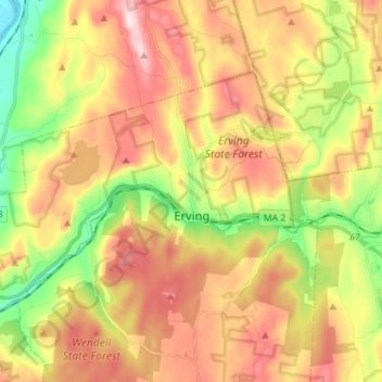
Name: Erving topographic map, elevation, terrain.
Location: Erving, Franklin County, Massachusetts, 01344, United States (42.57395 -72.50373 42.63928 -72.36230)
Average elevation: 255 m
Minimum elevation: 54 m
Maximum elevation: 453 m
Make a donation
Other topographic maps
Click on a map to view its topography, its elevation and its terrain.
North Sunderland
United States > Massachusetts > Franklin County > Sunderland
Average elevation: 100 m
Make a donation
Make a donation