
Thank you for supporting this site ❤️
Make a donation
Make a donation
Westmalle topographic map
Click on the map to display elevation.
Thank you for supporting this site ❤️
Make a donation
Make a donation
About this map
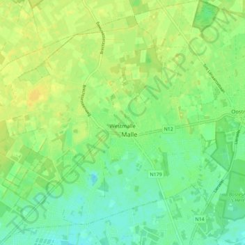
Name: Westmalle topographic map, elevation, terrain.
Location: Westmalle, Malle, Anvers, Flandre, 2390, Belgique (51.27250 4.63369 51.32684 4.71813)
Average elevation: 23 m
Minimum elevation: 13 m
Maximum elevation: 32 m
Thank you for supporting this site ❤️
Make a donation
Make a donation
Other topographic maps
Click on a map to view its topography, its elevation and its terrain.