
Lancaster County topographic map
Interactive map
Click on the map to display elevation.
About this map
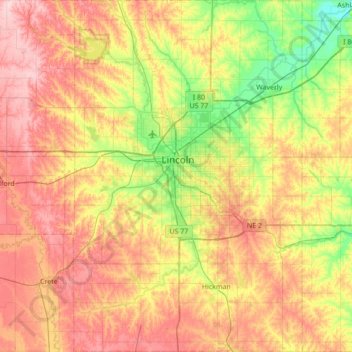
Name: Lancaster County topographic map, elevation, terrain.
Location: Lancaster County, Nebraska, United States (40.52301 -96.91393 41.04612 -96.46363)
Average elevation: 401 m
Minimum elevation: 324 m
Maximum elevation: 490 m
Other topographic maps
Click on a map to view its topography, its elevation and its terrain.
Lincoln
United States > Nebraska > Lancaster County
Lincoln, Lancaster County, Nebraska, United States
Average elevation: 379 m
Lincoln
United States > Nebraska > Lancaster County > Lincoln
Lincoln, Lancaster County, Nebraska, 68508, United States
Average elevation: 387 m
Landon's
United States > Nebraska > Lancaster County > Lincoln
Landon's, Lincoln, Lancaster County, Nebraska, United States
Average elevation: 360 m