Geolocate

Hallandsåsen topographic map

Click on the map to display elevation.

About this map

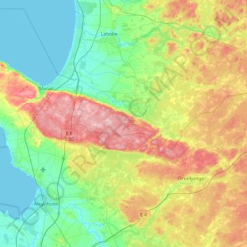
Name: Hallandsåsen topographic map, elevation, terrain.

Location: Hallandsåsen, Skåne County, 286 92, Sweden (56.27828 12.73821 56.46228 13.44829)

Average elevation: 71 m

Minimum elevation: -1 m

Maximum elevation: 222 m

Other topographic maps

Click on a map to view its topography, its elevation and its terrain.

Stockholm

Sweden > Stockholm County

Average elevation: 26 m

Skåne County

Sweden

Average elevation: 44 m

Malmö

Sweden > Skåne County > Malmö

Average elevation: 15 m

Lund

Sweden > Skåne County

Average elevation: 42 m

Gothenburg

Sweden > Västra Götaland County

Average elevation: 45 m

Söderhamn

Sweden > Gävleborg County

Average elevation: 24 m

Särö

Sweden > Halland County

Average elevation: 8 m

Västerås kommun

Sweden > Västmanland County

Average elevation: 34 m

Lund

Sweden > Skåne County

Average elevation: 42 m

Värmdö kommun

Sweden > Stockholm County

Average elevation: 9 m

Sturefors

Sweden > Östergötland County

Average elevation: 81 m

Torestorp

Sweden > Västra Götaland County

Average elevation: 100 m

Kalmar County

Sweden

Average elevation: 62 m

Östergötland County

Sweden

Average elevation: 83 m

Province of Södermanland

Sweden

The terrain is flat, with its highest altitude being Skogsbyås at 124 m (407 ft) elevation. The terrain largely consists of water filled hollows covered with woods on the heights.

Average elevation: 23 m

Västmanland County

Sweden

Average elevation: 75 m

Province of Hälsingland

Sweden

The terrain is mostly hilly and rocky, sloping down towards the coast. The highest elevation in the northern part is 530 meters, and 671 meters in the western part. Approximately 85% of the land area is covered with forest, and the timber industry has historically been the main source of income. Apart from…

Average elevation: 182 m

Slussen

Sweden > Västra Götaland County

Average elevation: 35 m

Strömmen

Sweden > Västra Götaland County

Average elevation: 128 m

Uppsala

Sweden > Uppsala County

Situated on the fertile Uppsala flatlands of muddy soil, the city features the small Fyris River (Fyrisån) flowing through the landscape surrounded by lush vegetation. Parallel to the river runs the glacial ridge of Uppsalaåsen at an elevation around 30 m (98 ft), the site of Uppsala's castle, from which…

Average elevation: 29 m

Piteå

Sweden > Norrbotten County

Average elevation: 10 m

Åstorps kommun

Sweden > Skåne County

Average elevation: 44 m

Mölle

Sweden > Skåne County

Average elevation: 29 m

Mundekulla

Sweden > Kalmar County

Average elevation: 143 m

Province of Västergötland

Sweden

Average elevation: 126 m

Lekeryd

Sweden > Jönköping County

Average elevation: 235 m

Staffanstorps kommun

Sweden > Skåne County

Average elevation: 26 m

Sjötofta

Sweden > Västra Götaland County

Average elevation: 183 m

Fellingsbro

Sweden > Örebro County

Average elevation: 28 m

Örebro kommun

Sweden > Örebro County

Average elevation: 64 m

Saittarova

Sweden > Norrbotten County

Average elevation: 233 m

Stockholm

Sweden > Västra Götaland County > Stockholm

Average elevation: 79 m

Scandinavia

Sweden

Average elevation: 125 m

Onsala

Sweden > Halland County

Average elevation: 15 m

Östorp

Sweden > Stockholm County

Average elevation: 72 m

Skiråsen

Sweden > Västerbotten County

Average elevation: 317 m

Lönshult

Sweden > Kronoberg County > Pjätteryd

Average elevation: 142 m

Stora Herrestad

Sweden > Skåne County

Average elevation: 32 m

Hagfors kommun

Sweden > Värmland County

Average elevation: 257 m

Linköping

Sweden > Östergötland County

Average elevation: 76 m

Norrbotten County

Sweden

Average elevation: 409 m

Hammar

Sweden > Örebro County

Average elevation: 97 m

Remma

Sweden > Västra Götaland County

Average elevation: 239 m

Mundekulla

Sweden > Kalmar County

Average elevation: 143 m

Ramsjö

Sweden > Gävleborg County

Average elevation: 245 m

Emmaboda kommun

Sweden > Kalmar County

Average elevation: 141 m

Sigtuna kommun

Sweden > Stockholm County

Average elevation: 26 m

Berget

Sweden > Västra Götaland County

Average elevation: 14 m

Östbyn

Sweden > Västerbotten County > Sikeå

Average elevation: 23 m

Voxlöv

Sweden > Halland County

Average elevation: 28 m

Margretetorp

Sweden > Skåne County

Average elevation: 80 m

Abisko National Park

Sweden > Norrbotten County

Permafrost is common in the national park, though permafrost at lower elevations is disappearing because of global warming and increased snowfall.

Average elevation: 740 m

Runsvik

Sweden > Västernorrland County > Tuna District

Average elevation: 69 m

Fiskarhagen

Sweden > Stockholm County

Average elevation: 26 m

Arjeplogs kommun

Sweden > Norrbotten County

Average elevation: 680 m

Malungsfors

Sweden > Dalarna County

Average elevation: 318 m

Rörums sommarby

Sweden > Skåne County

Average elevation: 36 m

Båstad

Sweden > Skåne County

Average elevation: 79 m

Sundsvall

Sweden > Västernorrland County

Average elevation: 70 m

Hammarö kommun

Sweden > Värmland County

Average elevation: 45 m

Norrbotten County

Sweden

Average elevation: 409 m

Norra Vånga

Sweden > Västra Götaland County

Average elevation: 106 m

Södertälje

Sweden > Stockholm County

Due to its topography and the fact that it is divided by a canal, it has been difficult to build good train connections in and through the city. Despite this, Södertälje is one of the largest railway hubs in Sweden. When the railway to Södertälje was commissioned, it was decided that the main line would…

Average elevation: 32 m

Lindby

Sweden > Stockholm County > Ekerö kommun

Average elevation: 8 m

Stret

Sweden > Jönköping County

Average elevation: 174 m

Södertälje

Sweden > Stockholm County

Due to its topography and the fact that it is divided by a canal, it has been difficult to build good train connections in and through the city. Despite this, Södertälje is one of the largest railway hubs in Sweden. When the railway to Södertälje was commissioned, it was decided that the main line would…

Average elevation: 32 m

Idre

Sweden > Dalarna County

Average elevation: 484 m

Hammarö kommun

Sweden > Värmland County

Average elevation: 45 m

Södertälje

Sweden > Stockholm County

Due to its topography and the fact that it is divided by a canal, it has been difficult to build good train connections in and through the city. Despite this, Södertälje is one of the largest railway hubs in Sweden. When the railway to Södertälje was commissioned, it was decided that the main line would…

Average elevation: 32 m

Nipfjället

Sweden > Jämtland County

Average elevation: 858 m

Idre fjäll

Sweden > Dalarna County

Average elevation: 677 m

Gullringen

Sweden > Kalmar County

Average elevation: 140 m

Ramundberget

Sweden > Jämtland County

Average elevation: 964 m

Haparanda

Sweden > Norrbotten County

Average elevation: 8 m

Röshult

Sweden > Västra Götaland County

Average elevation: 292 m

Täby kommun

Sweden > Stockholm County

Average elevation: 21 m

Sigtuna

Sweden > Stockholm County

Average elevation: 21 m

Padjelanta

Sweden

Average elevation: 824 m

Sarek

Sweden

Sarek National Park is the most mountainous region in Sweden and it is the part of the country that mostly resembles an alpine countryside. Within the park are 19 summits higher than 1,900 m (6,200 ft), the most noted being the second highest summit in Sweden after the Kebnekaise – the Sarektjåkkå with a…

Average elevation: 994 m

Gothenburg

Sweden > Västra Götaland County

Average elevation: 45 m

Fulufjället

Sweden > Dalarna County

Average elevation: 701 m

Städjan

Sweden > Dalarna County

Average elevation: 863 m

Åre

Sweden > Jämtland County

Average elevation: 590 m

Falun

Sweden > Dalarna County

Average elevation: 184 m

Ljungskile

Sweden > Västra Götaland County

Average elevation: 53 m

Scandinavian Peninsula

Sweden > Jämtland County

Its highest elevation was Glittertinden in Norway at 2,470 m (8,104 ft) above sea level, but since the glacier at its summit partially melted, the highest elevation is at 2,469 m (8,100 ft) at Galdhøpiggen, also in Norway. These mountains also have the largest glacier on the mainland of Europe, Jostedalsbreen.

Average elevation: 577 m

Kågeröd

Sweden > Skåne County

Average elevation: 82 m

Buskhyttan

Sweden > Södermanland County

Average elevation: 19 m

Stockholm

Sweden > Stockholm County

Average elevation: 26 m

Mulestad

Sweden > Kalmar County

Average elevation: 122 m

Gunnars

Sweden > Jämtland County

Average elevation: 826 m

Falköping

Sweden > Västra Götaland County

Average elevation: 239 m

Odensvi

Sweden > Västmanland County

Average elevation: 42 m

Kode

Sweden > Västra Götaland County

Average elevation: 36 m