
Thank you for supporting this site ❤️
Make a donation
Make a donation
Täby kommun topographic map
Click on the map to display elevation.
Thank you for supporting this site ❤️
Make a donation
Make a donation
About this map
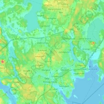
Name: Täby kommun topographic map, elevation, terrain.
Location: Täby kommun, Stockholm County, Sweden (59.41218 17.98175 59.51116 18.15373)
Average elevation: 21 m
Minimum elevation: -4 m
Maximum elevation: 93 m
Thank you for supporting this site ❤️
Make a donation
Make a donation
Other topographic maps
Click on a map to view its topography, its elevation and its terrain.