
Elma topographic map
Interactive map
Click on the map to display elevation.
About this map
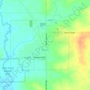
Name: Elma topographic map, elevation, terrain.
Location: Elma, Howard County, Iowa, United States (43.23825 -92.45062 43.25320 -92.42655)
Average elevation: 366 m
Minimum elevation: 351 m
Maximum elevation: 392 m
Other topographic maps
Click on a map to view its topography, its elevation and its terrain.
Riceville
United States > Iowa > Howard County
Riceville, Howard County, Iowa, 50466, United States
Average elevation: 376 m
Protivin
United States > Iowa > Howard County
Protivin, Howard County, Iowa, 52163, United States
Average elevation: 359 m
Cresco
United States > Iowa > Howard County > Cresco
Cresco, Howard County, Iowa, 52136, United States
Average elevation: 380 m